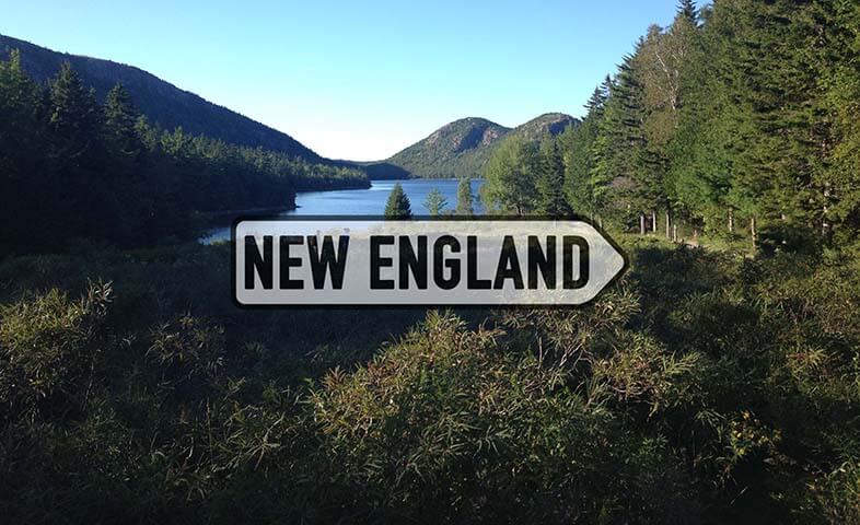
A Case for Bears Ears
By Courtney Johnson
With five national parks and over forty state parks to visit in Utah, the Cedar Mesa region in the southeast part of the state—where President Obama designated Bears Ears monument—has been most renowned for being a point of controversy. I journeyed to Bears Ears to better acquaint myself with the landscape as an outdoor enthusiast, and to better understand why so many people have fought so hard to protect it, for so many decades. I also wanted to be able to make a case for this particular body of land that is based on my own experience.
What was once territory that only families of Mormon settlers and indigenous peoples had a vested interest in preserving for its history, the area has been quickly growing as a recreational destination in the past decade. Cragging at Indian Creek and floating on the Colorado and San Juan rivers has brought climbers, paddlers and rafters to the area. The abundance of cycling trails and the opportunity to hike and backpack to ancient ruins also has outdoor enthusiasts flocking to the area in increasing numbers.
Mormon settlers first forged the Hole-in-the Rock trail between 1879-1880. Today, families with direct descent from those first pioneers call the towns of Bluff, Monticello and Blanding home. Amongst these settlers, a debate exists over how best to make use of this land. Many believe that they should be able to let their livestock graze, sell the artifacts they have uncovered while exploring, and allow mineral leasing and oil and gas operations. For some, this is about more than land—the area also represents the possibility of jobs and increased livelihood. More than 30 tribes also have ancestral ties to this area, from the Ute and Navajo to the Hopi and Paiute, and the Cedar Mesa area, including Bears Ears, serves many purposes. The ruins of former dwellings and granaries, pictographs and petroglyphs, fragments of pottery and arrowheads tell and protect stories of lineage, while traditional uses of the land—from fishing and hunting to wood gathering and plant foraging for medicine—are also essential.

Photo by Bob Wick, BLM
Although the first call to protect Bears Ears came over 80 years ago, since 2010 five specific tribes as a part of the sovereign Bears Ears Inter-Tribal Coalition (the Navajo, the Hopi, the Ute Mountain Ute, the Ute Indian Tribe of the Uintah and Ouray Reservation, and the Zuni) began lobbying persistently for protection of the land. The tribes set aside some differences to unite in a preservation effort, as not everyone agreed with the goal of monument status. Some wanted more control within the tribes as to how to regulate the land. Some feared what giving the government that much control would mean. Others thought monument status would bring too many visitors to sacred land.
Their efforts paid off in 2016, when President Obama proclaimed the new 1.35 million-acre Bears Ears National Monument in southeastern Utah. Two agencies were designated to protect the area, with 290,000 acres protected by the U.S. Forest Service and 1 million acres by the Bureau of Land Management. The name "Bears Ears" is inspired by two twin buttes that dominate the sky some 9,000 feet above sea level, and the land included in the national monument was to protect, for present and future generations, "the historic, scientific, commemorative, and cultural values of the archaeological and historic sites and structures on these lands.”
The status of Bears Ears changed drastically when President Trump, under the guise of Secretary of the Interior Ryan Zinke, shrunk Bears Ears to just 200,000 acres in December of 2017. Taking effect in early February 0f 2018, the 200,00 acres were divided into two territories, Indian Creek at 86,447 acres while Shash Jáa is 142,337 acres.
Currently this public land debate remains in the spotlight, with multiple lawsuits pending. Presently in the House is bill H.R. 4532, to remove the name Bears Ears all together and establish the two separate monuments of Shash Jáa and Indian Creek. Per this bill would be the first tribally managed national monument—but the only part of this bill that truly supports the Bears Ears Inter-Tribal Coalition's initial agenda for protecting the land is the withdrawal of approximately 1.35 million acres (as specified in Presidential Proclamation 9558) from future mineral leasing.
Historically, no president has taken away a national monument declared by a past president. The most frequented areas of the ruins in Utah, including Moon House and Doll House, Mull Canyon and the Butler Wash Kachina Panel, are still under monument status. But approximately 100,000 archaeological sites, many that remain undocumented, have now lost protection from looting and vandalism. In mid-February of this year, it was announced that one of the largest concentrations of Triassic- period fossils were found in an area within the original monument boundaries, but they are now no longer safeguarded.

Photo by Bob Wick, BLM
Around 80% of the rivers originally covered under Obama’s declaration are also no longer covered. Canyoneering access has been greatly decreased, while miles of mountain bike trails and hiking trails, accessing areas like Lady in the Bathtub and Castle Butte in the Valley of the Gods, rock art in Moqui Canyon and pictographs in Grand Gulch are no longer protected. Companies and citizens can file oil, gas and mineral claims for any of the land no longer included in the monument status.
***
I became curious during the course of researching my book on hiking in Utah—at the core, what really makes this place so special? Why have people dedicated their lives to protecting and preserving this land? To better know this unknown southeastern desert landscape, I set off on a solo trip, leaving my husband and daughter on their own for a few days.
The air was cool, and the sun was just beginning to peak up over the horizon as I drove the hour to the Ken Gulch Ranger Station in Cedar Mesa. I wanted to get an early start, both nervous about the miles ahead and knowing that I didn’t want to feel rushed as the day progressed. Today, I was hiking ten plus solo miles from the ranger station in Kane Gulch past the Junction and Turkey Pen ruins to Stimper Arch and back.
Just after 8:00 a.m., I checked in at the station and paid my $2 land use fee. Meager in amenities, the station was busy with backpackers and day hikers purchasing overnight camping permits and securing their routes with the guidance of volunteer rangers. Spending months at a time living behind the ranger station, each of them were more than eager to share their why this place speaks to them.

Photo by Courtney Johnson
I was sure to sign in on the registry, since I was hiking solo. I felt a tremendous sense of peace from the start of my hike into Ken Gulch. While a few birds chirped, most of the beginning miles of my hike were silent. I felt small surrounded by the walls of sandstone that rose into the sky. My mind, which is most often racing, was as still as the just starting to bud Cottonwood and Aspen clone trees that line parts of the trail.
I never spend more than one night away from my now four and a half year old, and this escape came at a time I needed it the most. While seeing the landscape through the eyes of a child includes its own unique perspective, I was much looking forward to not having to answer a million questions or pull out snacks every 15 minutes.
I had been also internally struggling with many things in my life— the pain of loss, an inner unrest about what I want my life to be, questions about my parenting style, and other life choices. The winter by us hadn’t been bad, but a part of me still needed to disconnect from the daily grind.
Out there, I found a peace that I have only been experiencing recently for short periods of time, while on my yoga mat. It didn’t take me long to understand what makes this place unique, and my desire to know this threatened place on a deeper level grew. Nature’s pharmacy lines the trail with yarrow and prickly pear cactus. Just starting to flower, these plants encourage a sense of healing, especially within their native habitat.
I imagined children playing with balls made of mud while their mothers made maize from the Three Sisters, corn, beans and squash. Men work to fill the granaries high above in the canyons, storing essentials for living. The sandstone was covered in salt deposits in some places, turning the red walls to white as I made my way over the slickrock and down into some areas of wash. While researching the hike online, I saw playful images of adults and children pretending to be pushing up on a large rock balanced on an angle and now almost cemented naturally to a slab of sandstone. While Arches has a more impressive Balance Rock, I consider this the Balance Rock of Kane Gulch.
As I tried to take a horrible selfie (think T-rex short arms), a fellow female hiker came to my rescue. A social worker from Grand Junction, who often drove to Utah to experience the beauty, we hiked together for a bit. I told her about my book and she shared with me how she seeks refuge on her days off amongst the buttes and vistas of Utah after the traumas she sees in her everyday work.

Photo courtesy Courtney Johnson
We parted ways a half a mile later; while meeting a new friend that shares the same passions is always pleasant, we needed to experience the magic of the wilderness on our own—to find ourselves in this solitary stretch of earth.
My mind wandering freely, I somehow missed the turnoff (around the 3.5 mile mark) for the Junction Ruins, Built on three levels and at the location where Kane and Grand Gulch meet, Junction Ruins is a large cliff dwelling that served as dwellings and places of worship for the Anasazi.. A bit further along the trail, I passed two older gentleman that had left the ranger station before me. They seemed a bit perplexed as well. “Have you ever hiked this before,” they asked. I told them no, while in the back of mind knowing that I would be back soon. I had a deep desire to take my daughter Emma back here to experience the magic of this place. Fostering an appreciation for culture and the great outdoors has been a parental goal from birth for my husband AJ and I.
I continued on past the two men, deciding to check my Gaia GPS for piece of mind that I hadn’t missed a turn or two. Knowing that GPS can often be off, especially in the wilderness, I decided to keep on the track I was heading, knowing I could always see the Junction Ruins on my return to the ranger station.
Climbing up and out of the wash, I took a moment to sit on a downed tree; I found myself reflecting on what brought me to where I am, and where I see myself going. I imagine many who have passed here have had several of these moments, with renewed hope for the future. A few deep breaths were the only sounds I heard as I inhaled the canyon air, ripe with the smell of the Utah pines, that surrounded me.
As I continued on, several trails along the way intrigued me. Consulting my GPS, I noted that I would near the Turkey Pen Ruins approximately 4.5 miles from the start of the hike. I decided to take one of the northbound trails, away from the wash and closer to the sandstone walls that create the canyon.
Ascending up a hill of sand, the Turkey Pen Ruins soon came into view. Located under an alcove, the ruins were built between 1000 and 1250 AD by the Anasazi. Many areas are not accessible due to rocks falls and erosion, including the second level. Shards of pottery and corn cobs, amazingly still well intact, scattered the roped off areas of the site. On the hillside is a roofless structure with a south opening, where sticks covered with mud remain but are roped off by the BLM. This is what gave the ruins its name, but the likelihood it held turkeys at one time is questionable.

Photo by Courtney Johnson
At the top, I paused and took a few deep breaths while looking out. At peace and alone, I began to do some sun salutations- Sūrya Namaskāra. I spent some quiet moments observing the pit houses, noticing how the dwellings reflected a simpler way of living—a balance I am striving for in my own life.
I didn’t get too much time to explore the ruins before I heard the voices of the two men I had passed earlier. Over lunch, we discussed the ruins and our lives at home. They were from the east coast, taking a swing through Utah while their non-hiking wives stayed home in New Hampshire. I explained that the past three trips I had taken with my family to Utah were filled with hikes in the desert and that my daughter and husband were red sanded out.
They had also missed the turnoff for Junction Ruins, so they invited me to join them to Stimper Arch with a stop at Junction Ruins on the way back to the trailhead. Before we left Turkey Pen, the social worker I encountered earlier made her way up to the ruins. She decided to join us on the short distance to Stimper Arch, but would continue on into Grand Gulch solo.
With a span of 20 feet and an opening height of six feet, Stimper Arch is surrounded by black desert varnish made from manganese and iron. Surrounded by wall of rock, it is different than many of the other natural arches in Utah, in that you can’t go under it.
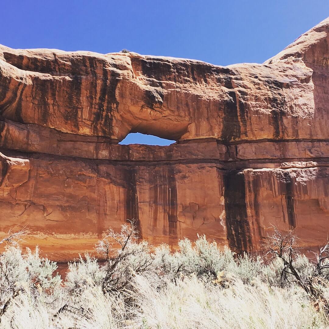
Photo courtesy Courtney Johnson
After some moments discussing the arch, my two new friends from New Hampshire and I turned back and headed back towards Ken Gulch and Junction Ruins. Knowing better where to look, it was easy to see Junction Ruins through the just budding cottonwoods when heading east on the trail. Junction Ruins is built on three levels, at the location where Kane and Grand Gulch meet. Two levels are still accessible, while the third needs a ladder and some gusto to access. I stayed below with one of my new hiking friends, exploring the more expansive ruin site, while the other went to access the second floor.
Rooms of habitation and kivas stand protected by an overhang of sandstone. Some structures look defensive in nature. Pictographs on the walls tell stories of the past. I explored the area, making my own solitary path between the buildings. After a few last moments looking at the broken pottery pieces left behind, we began the climb out of Kane Gulch.
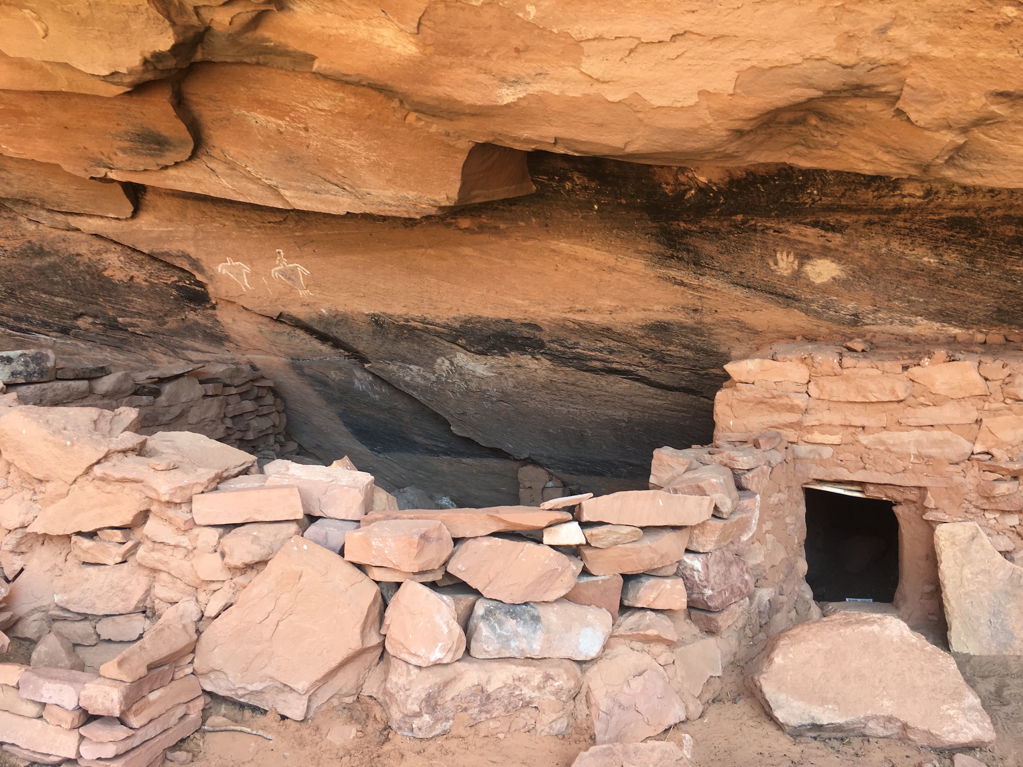
Photo courtesy Courtney Johnson
Our conversation on the way back to the ranger station focused on the many blessings and things we were thankful for in our own lives—supportive family, good friends, and the ability to take time for the things we value in life. Whenever we stopped to take in the view, or for a drink of water in the ever warming canyon, we were silent, experiencing quietly the natural wonders before us.
Because of the desert environment, many of the animals that call the Cedar Mesa area home are nocturnal, including the gray fox, badger, and mountain lion. However, as we inched closer to the trailhead, we were lucky enough to encounter two women from Durango with a hiking cat. Yes, a cat that hikes a mile or so at a time and then hitches a ride on the owners back when tired. That made for an interesting story when I returned from my trip!

Photo courtesy Courtney Johnson
Before crossing the main road and returning to my car, I turned and stood for a minute, looking back into Kane Gulch. Threatened natural environments seem to always stir controversy. My case for Bears Ears purely comes from the standpoint of an outdoor enthusiast. I am grateful for the solitude and community I experienced while there—it gave me a sense of hope and inspiration, and of good adventures to come. I left with renewed clarity and deeper appreciation of the simple truth that you cannot learn a place, or advocate for it in the same way, until you experience it for yourself.
Also in Utah, Grand Staircase-Escalante National Monument was also reduced to 1,003,863 acres- almost half the original size from its original monument designation by former President Bill Clinton in 1996 of 1,880,461 acres.

Courtney Johnson is a freelance sports and parent writer based in Erie, Colorado. She enjoys spending time outdoors with her husband AJ and five year old daughter Emma. Her first book will be coming out in spring 2019 about hiking with kids in Utah. Follow her adventures at http://adventureswithmylittleray.com/.